A Severe Weather Warning and Flood Warning for the Wimmera River are both currently in place.
A low pressure system over South Australia is forecast to move into North West Victoria late Tuesday. A band of rain is associated with the low, along with the risk of thunderstorms. Rain is expected to ease to showers in the far northwest during Wednesday morning.
Widespread rainfall totals of 20 to 40 mm are forecast for the Campaspe, Loddon, Avoca and Wimmera river catchments overnight Tuesday into Wednesday. Heavy rain or thunderstorms may cause localised falls in excess of 50 mm.
Catchments in the North West are saturated. With the forecast rainfall, significant stream rises are expected in the Campaspe, Loddon, Avoca and Wimmera catchments, with renewed minor to moderate flooding developing from Wednesday morning.
5pm - Major Flood Warning for Wimmera River
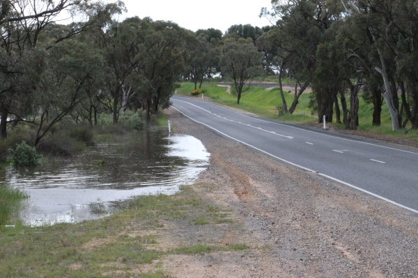
Major flooding is occurring along the Wimmera River around and downstream of Quantong Bridge.
Since 9 am Monday, no significant rainfall has been recorded in the Wimmera River catchment. A band of rain is forecast for Tuesday evening and overnight into Wednesday, bringing widespread rainfall totals of 20-40 mm for the Wimmera River catchment and potentially higher localised totals due to thunderstorms.
The forecast rainfall is expected to cause significant renewed river rises, with minor flooding likely to redevelop in the upper Wimmera River catchment from Wednesday evening.
Wimmera River to Glenorchy:
Minor flooding may occur along the Wimmera River to Glenorchy.
The Wimmera River at Glenorchy is currently at 0.96 metres and steady. The Wimmera River at Glenorchy may exceed the minor flood level (4.00 m) Wednesday evening.
Wimmera River Glenorchy to Horsham:
Moderate flooding is occurring along the Wimmera River Glenorchy to Horsham.
The Wimmera River at Horsham (Walmer) is currently at 2.97 metres below the moderate flood level (3.10 metres) and falling. The Wimmera River at Horsham (Walmer) is expected to fall below the minor flood level (2.80 m) overnight Tuesday into Wednesday.
Wimmera River downstream of Horsham:
The Wimmera River at Quantong Bridge peaked at 6.61 metres (major flood level 5.9 metres) during Monday evening and is currently at 6.44 metres and falling slowly.
The Wimmera River U/S Dimboola is currently at 4.74 metres and rising. The Wimmera River U/S Dimboola is expected to remain below the minor flood level (5.3 metres).
2:20pm - Local Road Closures, via Hindmarsh Shire Council
A reminder to all people that floodwater is dangerous - never drive, walk or ride through floodwater.
The following roads are closed:
Swallows Lane: Road closed at Dimboola Rainbow Rd intersection and at the River end of Swallows Lane.
Bothe Rd: Road Closed at Dimboola Rainbow Rd intersection.
Boat Ramp Dimboola Township (Lloyd St) and Ski Club: Road Closed
Boat Ramp Jeparit Township (Peterson Rd) and Ski Club: Road Closed
Collard Rd: Road Closed at Glatz Rd Intersection.
The following roads have water over road:
Spears Crossing: Road Closed at end of Limestone near Bill Eldridge's house gate.
River Road: Water Over Road at three locations from Adams Water Hole to Maringa Rd intersection.
Five Chain Rd: Water Over Road at invert near Dimboola Rainbow Rd and Road closed at Collard Rd intersection.
Klinge Rd: Water Over Road about 500m down towards the River.
Never Never Rd: Water Over Road, still from rain events.
11am - Severe Weather Warning
A low pressure system over South Australia is forecast to move into northwest Victoria late today. A band of rain is associated with the low, along with the risk of thunderstorms.
HEAVY RAIN which may lead to FLASH FLOODING is likely to reach far northwest Victoria late Tuesday afternoon, extend across the Mallee and parts of the Wimmera district during the evening, spreading to parts of the Southwest, Northern Country and North Central districts by midnight, then into the Northeast and parts of the Central district early on Wednesday morning.
Widespread totals of 20 to 40mm are forecast across the warning area, falling in a period of 4-8 hours. Heavy rain or thunderstorms may cause localised falls of 50 to 70mm.
Rain is expected to ease to showers in the far northwest during Wednesday morning.
Locations which may be affected include Mildura, Horsham, Bendigo, Shepparton, Seymour, Maryborough, Ballarat, Wodonga and Wangaratta.
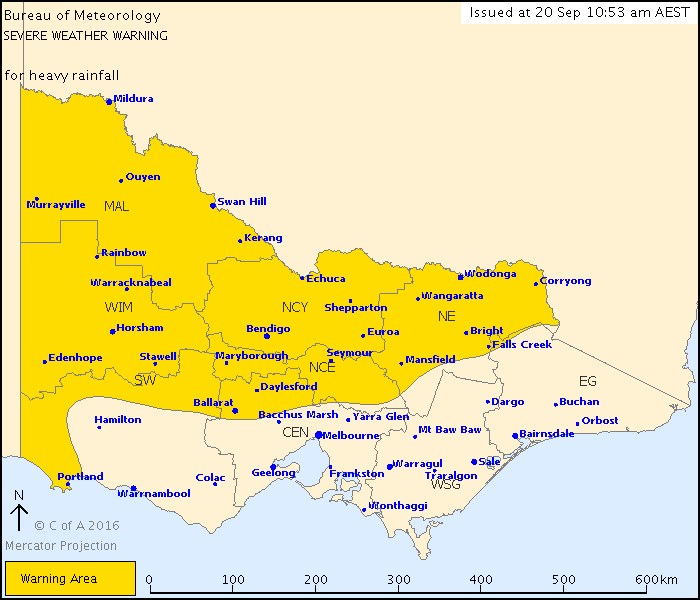
Image: BOM.
10am - A Major Flood Warning remains in place for the Wimmera River.
Major flooding is occurring along the Wimmera River around and downstream of Quantong Bridge.
Since 9 am Monday, no significant rainfall has been recorded in the Wimmera River catchment. A band of rain is forecast for Tuesday evening and overnight into Wednesday, bringing widespread rainfall totals of 15-30 mm for the Wimmera River catchment and potentially higher localised totals due to thunderstorms.
The forecast rainfall is expected to cause significant renewed river rises, with minor flooding likely to redevelop in the upper Wimmera River catchment from Wednesday evening.
Wimmera River Glenorchy to Horsham:
Moderate flooding is occurring along the Wimmera River Glenorchy to Horsham.
The Wimmera River at Horsham (Walmer) is currently at 3.13 metres (moderate flood level 3.10 metres at that location) and falling. The Wimmera River at Horsham (Walmer) is expected to fall below the moderate flood level Tuesday morning.
Wimmera River downstream of Horsham:
The Wimmera River at Quantong Bridge peaked at 6.61 metres (major flood level at that location 5.9 metres) during Monday evening and is currently at 6.55 metres and falling slowly.
The Wimmera River U/S Dimboola is currently at 4.72 metres and rising. The Wimmera River U/S Dimboola is expected to remain below the minor flood level (5.3 metres at that location).
Flood Safety Advice:
SES advises that all community members should:
Never walk, ride or drive through floodwater,
Never allow children to play in floodwater,
Stay away from waterways and stormwater drains during and after heavy rain,
Keep well clear of fallen power lines
Be aware that in fire affected areas, rainfall run-off into waterways may contain debris such as ash, soil, trees and rocks, and heavy rainfall increases the potential for landslides and debris across roads.
Wimmera River Heights:
Horsham (Walmer), 3.13m, Falling, 08:25 AM
Quantong Bridge, 6.55m, Falling, 08:36 AM
U/S Dimboola, 4.72m, Rising, 07:40 AM
Lochiel, 4.06m, Steady, 06:45 AM
Potential Impact In Your Area
The potential local impact of this flooding in your area may include:
Widespread flooding of farmland
Major roads and bridges may be closed or damaged by floodwater
Some areas of towns may flood and floodwater may enter homes
Power, water and sewerage may be cut-off
Towns and properties may be cut-off from surrounding areas
What You Should Do
Act now - take immediate precautions to protect your life and property
Be prepared to evacuate if advised by authorities
If you are likely to become isolated, make sure you have enough food, water, medication and pet food, and be aware that you may need to live without power, water and sewerage
Raise belongings by placing them on tables, beds and benches or move them to higher ground
Tune in to your emergency broadcasters: ABC Local Radio, commercial radio and designated community radio stations, or SKY NEWS Television
Block toilets, household drains, sinks and plugs to stop sewerage backflow
Floodwater is dangerous - never drive, walk or ride through floodwater
Floodwater is toxic - never play or swim in floodwater
Emergency Contacts
For flood or storm emergency assistance from the SES call 132 500
For life-threatening emergencies call 000
|