6pm Update - Moderate Flood Warning
The Major Flood Warning has been downgraded to a moderate flood warning for the Wimmera River.
Moderate flooding is continuing along the Wimmera River around and downstream of Quantong Bridge.
No further significant rainfall is forecast for the remainder of Wednesday and flooding is no longer expected to redevelop in the upper Wimmera River catchment .
Wimmera River downstream of Horsham:
The Wimmera River at Quantong Bridge is currently above the moderate flood level (5.4 metres) at 5.86 metres and falling.
River Levels
Wimmera River at Horsham (Walmer) - 2.25m, Steady (05:11 PM)
Wimmera River at Quantong Bridge - 5.87m, Steady (05:12 PM)
Wimmera River U/S Dimboola - 4.54m, Steady (05:06 PM)
Wimmera River at Lochiel - 4.15m, Steady (02:45 PM)
4pm - Flood Community Update for the Wimmera River
Major flooding is continuing along the Wimmera River around and downstream of Quantong Bridge.
Since 9 am Tuesday rainfall totals of up to 7 mm have been recorded in the Wimmera River catchment. Less than 5 mm of rain is forecast for the remainder of Wednesday.
Flooding is no longer expected to redevelop for the upper Wimmera River catchment based on todays forecast rainfall.
Wimmera River Glenorchy to Horsham:
Flooding is no longer occurring along the Wimmera River Glenorchy to Horsham.
The Wimmera River at Horsham (Walmer) fell below the minor flood level (2.80 metres) during Tuesday evening and is currently at 2.58 metres and falling.
River levels for the Wimmera River at Horsham (Walmer) will continue to fall during Wednesday.
Wimmera River downstream of Horsham:
The Wimmera River at Quantong Bridge peaked at 6.61 metres (major flood level 5.9 metres) during Monday evening and is currently at 6.13 metres and falling.
The Wimmera River U/S Dimboola peaked below the minor flood level (5.3 metres) during Tuesday evening and is currently at 4.57 metres and falling.
Road Closures, via Hindmarsh Shire Council
The following roads are closed:
River Road: at the Intersection of Krahe Rd, Maringa Rd and McKenzie Rd.
Maringa Rd: at intersection of Z2 Rd.
Ebenezer Mission Rd: at intersection of Dimboola Rainbow Rd.
Anderson St Dimboola: at end of seal at Dimboola Common.
Faith St Dimboola: at end of seal at Dimboola Common.
Moulder St Dimboola: at end of seal at Dimboola Common.
Normanby St Dimboola: at end of seal at Dimboola Common.
Dimboola Common Track: from Normanby st to Swallows Lane.
Swallows Lane: Road closed at Dimboola Rainbow Rd intersection and at the River end of Swallows Lane.
Bothe Rd: Road Closed at Dimboola Rainbow Rd intersection.
Boat Ramp Dimboola Township (Lloyd St) and Ski Club: Road Closed
Boat Ramp Jeparit Township (Peterson Rd) and Ski Club: Road Closed
Collard Rd: Road Closed at Glatz Rd Intersection.
A Major Flood Warning remains in place for the Wimmera River.
Major flooding is continuing along the Wimmera River around and downstream of Quantong Bridge.
Since 9 am Tuesday rainfall totals of up to 7 mm have been recorded in the Wimmera River catchment. Less than 5 mm of rain is forecast for the remainder of Wednesday.
Flooding is no longer expected to redevelop for the upper Wimmera River catchment based on todays forecast rainfall.
Wimmera River Glenorchy to Horsham:
Flooding is no longer occurring along the Wimmera River Glenorchy to Horsham.
The Wimmera River at Horsham (Walmer) fell below the minor flood level (2.80 metres) during Tuesday evening and is currently at 2.58 metres and falling. River levels for the Wimmera River at Horsham (Walmer) will continue to fall during Wednesday.
Wimmera River downstream of Horsham:
The Wimmera River at Quantong Bridge peaked at 6.61 metres (major flood level 5.9 metres) during Monday evening and is currently at 6.13 metres and falling.
The Wimmera River U/S Dimboola peaked below the minor flood level (5.3 metres) during Tuesday evening and is currently at 4.61 metres and falling.
Flood Safety Advice:
SES advises that all community members should:
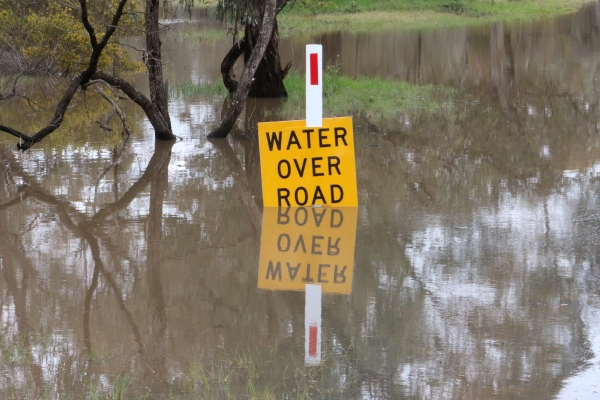
Never walk, ride or drive through floodwater,
Never allow children to play in floodwater,
Stay away from waterways and stormwater drains during and after heavy rain,
Keep well clear of fallen power lines
Be aware that in fire affected areas, rainfall run-off into waterways may contain debris such as ash, soil, trees and rocks, and heavy rainfall increases the potential for landslides and debris across roads.
Wimmera River Heights:
Horsham (Walmer), 2.58m, Falling, 07:11 AM
Quantong Bridge, 6.13m, Falling, 07:04 AM
U/S Dimboola, 4.67m, Falling, 06:40 AM
Lochiel, 4.15m, Steady, 06:45 AM
Potential Impact In Your Area
The potential local impact of this flooding in your area may include:
Widespread flooding of farmland
Major roads and bridges may be closed or damaged by floodwater
Some areas of towns may flood and floodwater may enter homes
Power, water and sewerage may be cut-off
Towns and properties may be cut-off from surrounding areas
What You Should Do
Act now - take immediate precautions to protect your life and property
Be prepared to evacuate if advised by authorities
If you are likely to become isolated, make sure you have enough food, water, medication and pet food, and be aware that you may need to live without power, water and sewerage
Raise belongings by placing them on tables, beds and benches or move them to higher ground
Tune in to your emergency broadcasters: ABC Local Radio, commercial radio and designated community radio stations, or SKY NEWS Television
Block toilets, household drains, sinks and plugs to stop sewerage backflow
Floodwater is dangerous - never drive, walk or ride through floodwater
Floodwater is toxic - never play or swim in floodwater
Emergency Contacts
For flood or storm emergency assistance from the SES call 132 500
For life-threatening emergencies call 000
|